This is an amazing app!!!!! It helps me to send my coordinates with picture to my clients to review.
1,000,000+
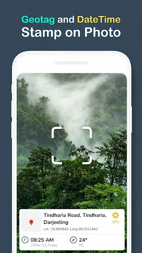
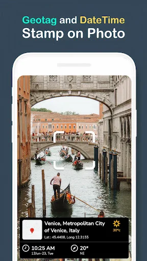
Never Forget Where Your Photos Were Taken
Automatically stamp every photo with location, date, time, and weather data. Perfect for professionals documenting work sites and travelers capturing memories with complete context.
1,000,000+
Never Forget Where Your Photos Were Taken
Automatically stamp every photo with location, date, time, and weather data. Perfect for professionals documenting work sites and travelers capturing memories with complete context.
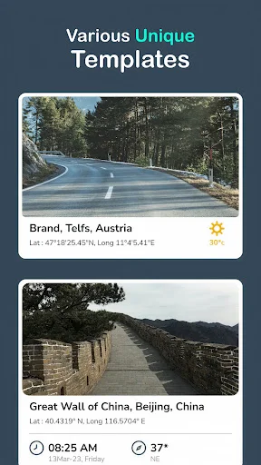
Everything Your Photos Need in One Tap
1
Automatic Location Stamping
Every photo you take is instantly tagged with GPS coordinates, address, and timestamp. No extra steps needed – just point, shoot, and your documentation is complete.
2
Professional Photo Verification
Add compass direction, temperature, altitude, and weather conditions to every shot. Your photos gain credibility and provide the proof clients, colleagues, and followers need.
3
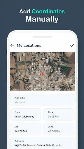
Multiple Design Templates
Choose from various stamp designs that fit your style and purpose. Whether for construction sites, real estate, travel blogs, or field reports, there's a template that looks professional.
4
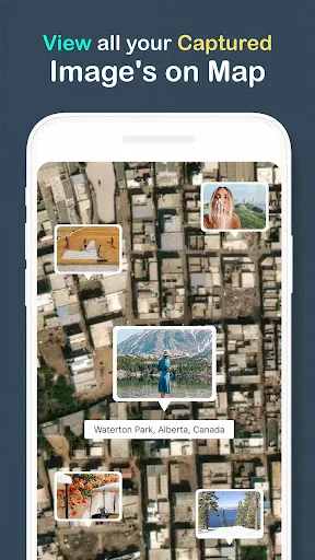
Perfect for Work and Adventure
From documenting construction progress to capturing mountain hikes, this app adapts to your needs. Field workers, travelers, real estate agents, and content creators all benefit from verified photo documentation.
1
Automatic Location Stamping
Every photo you take is instantly tagged with GPS coordinates, address, and timestamp. No extra steps needed – just point, shoot, and your documentation is complete.
2
Professional Photo Verification
Add compass direction, temperature, altitude, and weather conditions to every shot. Your photos gain credibility and provide the proof clients, colleagues, and followers need.
3
Multiple Design Templates
Choose from various stamp designs that fit your style and purpose. Whether for construction sites, real estate, travel blogs, or field reports, there's a template that looks professional.
4
Perfect for Work and Adventure
From documenting construction progress to capturing mountain hikes, this app adapts to your needs. Field workers, travelers, real estate agents, and content creators all benefit from verified photo documentation.
About
GPS Map Camera Lets You Tag Your Memories as You Travel
With the GPS Map Camera Photo Location app, you never have to remember where or when you snapped a photo. This app works all the time when you are traveling, working in the field, or capturing a moment in time, to provide useful info to every photo. Wherever you take a photo, the app automatically adds the date and time, as well as the location.
GPS map camera photo with location and timestamp feature adds real time address, coordinates, compass direction, and temperature on the photo. This will be greatly useful to all adventurers, creators, and professionals.
Smarter Photos with GPS Built-In
This easy to use GPS map camera location app is your best friend when it comes to visual documentation. No matter your business or personal travel needs, with this app, knowing when and where a photo was taken becomes effortless and automatic. Just open the camera, select a template, and start snapping photos. No extra steps needed, the GPS map camera time stamp app is just that easy.
GPS Map Camera Photo Location Features you will love:
- Location and time of photos instantly stamped
- Access to many design templates
- Latitude, longitude, weather and compass info added
- Stamps to your photos are easy to save or share
- Reliable GPS map camera time stamp available anywhere
If you are a civil engineer capturing your job site or a blogger capturing a road trip, the GPS camera location feature provides your pictures with much more depth and credibility. With the GPS map camera time stamp app, your clients, co-workers, and followers will appreciate the exact location you captured the photos.
Perfect for All Users
The GPS Map Camera Photo Location app is perfect for all users:
- Field specialists wanting to keep photographic records
- Real estate and architectural firms
- Travellers and adventurers wanting to document their journeys
- Event managers wanting to document live events
- Storytellers and authors who want to enrich their narratives and incorporate GPS data
There is no need to guess or explain the visual content with the GPS Map Camera Photo with Location and Timestamp features, the visual content is clearer to the users and the photographs can stand on their own and provide verification to the information within them.
Capture, Stamp & Share
GPS Map Photos Location App can document the occasion and provide the right contextual information with customizable live stamp preview. Take ownership of the document at mountain hikes, event sites, and construction sites.
The built in GPS Map Camera Time Stamp allows photos to be verified more easily for work, school and social purposes. All users need to do is point and shoot, and they will have their photo ready in no time.
Every Photo Tells a Story
GPS camera location and map geotags help you document your life and help travelers document their journeys, professionals to keep track of their construction progress and people to send their locations to friends and family and share their real time photos.
GPS camera location and geotagging help you relive your moments with greater accuracy. Every photo you take is documented with an exact location and time with the GPS Map Camera Photo Location. Get the GPS Map Camera Location App Now!
Stop your memories from being forgotten. Start using the GPS map camera to photo location and time stamp your images and keep your memories forever. GPS camera location and map geotags stay photos business ready and more, so you can tell a unique story and pinpoint every photo's location.
See Your Photos Come Alive with Context
Trusted by Professionals and Travelers Worldwide
GPS Map camera very good application I use it to capture photos with location as I love to travel
It's a perfect and accurate in respect of locations description, latitude and longitude. I recommend its usage.
Fantastic so far highly accurate and stable, Its great for reporting with time in date
It is also very useful for Highway projects and Highway Maintenance works.
thus is one of the great apps to use, very easy to use this app & very helpful for remind the visited place & also very easy to mention the place in the social media posts.